Day 2 :
Keynote Forum
Nicolas H. Younan
Mississippi State University
USA
Keynote: High resolution Satellite precipitation estimation based on cloud classification
Time : 09:05-09:45

Biography:
Nicolas H. Younan is currently the Department Head and James Worth Bagley Chair of Electrical and Computer Engineering at Mississippi State University. He received the B.S. and M.S. degrees from Mississippi State University, in 1982 and 1984, respectively, and the Ph.D. degree from Ohio University in 1988. Dr. Younan’s research interests include signal processing and pattern recognition. He has been involved in the development of advanced signal processing and pattern recognition algorithms for data mining, data fusion, feature extraction and classification, and automatic target recognition/identification. He has published over 250 papers in refereed journals and conference proceedings, and book chapters. He served as the General Chair and Editor for the 4th IASTED International Conference on Signal and Image Processing, Co-Editor for the 3rd International Workshop on the Analysis of Multi-Temporal Remote Sensing Images, Guest Editor - Pattern Recognition Letters and JSTARS, and Co-Chair - Workshop on Pattern Recognition for Remote sensing (2008-2010)..
Abstract:
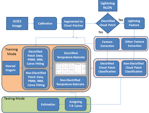
Satellite precipitation estimation at high spatial and temporal resolutions is beneficial for research and applications in the areas of weather, flood forecasting, hydrology, and agriculture. In this presentation, we incorporate advanced image processing and pattern recognition tools into the Precipitation Estimation from Remotely Sensed Information using Artificial Neural Networks Cloud Classification System (PERSIANN-CCS) methodology to enhance satellite precipitation and rainfall estimation. The enhanced algorithm incorporates five main steps to derive precipitation estimates: 1) segmenting the satellite infrared cloud images into patches, 2) extracting features from the segmented cloud patches, 3) feature selection or dimensionality reduction, 4) categorizing the cloud patches into separate groups, and 5) obtaining a relationship between the brightness temperature of cloud patches and the rain- rate (T-R) for every cluster. In addition to the features utilized for cloud patch classification, wavelet and lightning features are also extracted. Both feature selection and dimensionality reduction techniques are used to reduce the dimensionality as well as diminish the effects of the redundant and irrelevant features. A variety of feature selection techniques, such as Feature Similarity Selection and a Filter-Based Feature Selection using Genetic Algorithm are examined and the Entropy Index (EI) fitness function is used to evaluate the feature subsets. Furthermore, Independent Component Analysis was examined and compared to other linear and nonlinear unsupervised dimensionality reduction techniques to reduce the dimensionality and increase the estimation performance. The results show that the enhanced algorithm incorporating the above techniques improves precipitation estimation.
Keynote Forum
Dorian Gorgan
Technical University of Cluj-Napoca
Romania
Keynote: Visual analysis on multidimensional massive data
Time : 09:45-10:25

Biography:
Dorian Gorgan is Professor in Computer Science Department of the Technical University of Cluj-Napoca and PhD supervisor in Computers and Information Technology, and coordinator of the Computer Graphics and Interactive System Laboratory. His fields of interest involve parallel and distributed processing over HPC infrastructures such as Grid, Cloud, Multicore, and cluster, development of platforms and applications for spatial data processing and visualization, interdisciplinary research in the domains of Earth Sciences and Earth Observations. He has been involved as scientific coordinator and WP leader in national and international research projects such as BIGEARTH, PECSA, enviroGRIDS, IASON, SEE-GRID-SCI, GiSHEO, mEducator, iTRACE, MedioGrid, COMPLEXHPC, and KEYSTONE. He has been member of scientific and reviewing committees of many ISI journals and international conferences, and gave more than 350 papers and presentations in journals and prestigious conferences in the domains of Computer Science and Earth Observation.
Abstract:
Huge data are being generated by our everyday actions and the plethora of machines and sensors which surround us. This is especially true for the fields of study which regularly deal with Earth Science and Earth Observation data. The last decade has seen a dramatic increase in the data volumes available to the general public, and especially to creative people, in order to produce unexpected valuable results through flexible and adaptive approaches.
The high performance computation systems are able to satisfy the requirements for data transformation, classification, and highlighting of the significant data. Even so, the capacity of these systems for data analysis is quite limited. Nevertheless, the human brain has much more capacity for data analysis, synthesis and understanding. The human brain uses the greatest capacity of the visual channel to receive information. Therefore, combining the great computing capacity of the computer and, the visual analysis and reasoning of the human brain, could be an interesting and promising approach for data processing, mining and understanding.
The presentation highlights the solutions and issues of the visual analysis on multidimensional massive data. The experiments consider the n-dimensional value space of data and techniques for interactive navigation and visualization. The user may control the visualization and navigation in order to identify and detail the critical regions, points and tendencies within the value space. The examples cover use cases in the domains of Earth Science, Earth Observations and medicine.
Keynote Forum
Bo Huang
Chinese University of Hong Kong
Hong Kong
Keynote: Unified Satellite Image Fusion for Sustainable Urban Environment
Time : 10:45-11:25

Biography:
Bo Huang is a Professor in the Department of Geography and Resource Management, The Chinese University of Hong Kong, where he is also the Associate Director of Institute of Space and Earth Information Science and the Director of MSc Program in GeoInformation Science. He received Changjiang Scholar Chair Professorship, the highest academic award issued to an individual in higher education by the Ministry of Education of PR China. Dr. Huang’s research interest focuses on geographical information science and he has published extensively in this field, including over 100 refereed international journal articles. He currently serves as the Asia-Pacific Editor of International Journal of Geographical Information Science (Taylor & Francis). In recent years he has been exploring along the line of unified remote sensing image fusion, convinced that this new paradigm will revolutionize the way how remote sensing data are integrated, analyzed and utilized in the future.
Abstract:
The recent decades have witnessed the launch of a large number of orbiting satellite sensors with different spatial, temporal, spectral, and angular (STSA) characteristics, resulting in dramatic improvements in the ability to acquire images of the Earth surface, and a boom in remote sensing (RS) applications in environmental, ecological, and disaster monitoring. However, current RS technology cannot meet the requirement of monitoring dense and dynamic urban environments with complex structures and changes that require high spatial detail, frequent coverage, fine spectral resolution, and multi-angle observation. This is largely due to the fact that there is no satellite sensor that can achieve simultaneously high STSA resolution. Unified satellite image fusion aims to circumvent this obstacle by achieving high resolution with respect to all the image properties for a virtual satellite sensor. The generated high STSA resolution imagery can greatly contribute to the exploration and improvement of existing satellite image resources for urban environmental applications by detecting more details in a more accurate manner. This presentation will introduce to you the speaker’s endeavors along this line of research, including both the methodologies and applications in environmental and land use monitoring.
Keynote Forum
Ryspek Usubamatov
Kyrgyz State Technical University
Keynote: Fundamental principles of gyroscope theory
Time : 11:25-12:05

Biography:
Ryspek Usubamatov has graduated as professional engineer, completed Ph.D from Bauman Moscow State Technical University and Doctor of Technical Sciences from Academy of Sciences of Kyrgyzstan. He worked as an engineer-designer of machine tools at engineering company. He is a professor of Kyrgyz State Technical University and worked at universities in Malaysia. He has published more than 300 papers in reputed journals, more than 60 patents of inventions in engineering and seven books in area of manufacturing engineering. He supervised six Ph.D and several dozens of MSc. students. His research interests in area of Gyroscope theory and Productivity theory for Industrial Engineering.
Abstract:
Gyroscope devices are primary units for navigation and control systems in aviation, space, ships, and other industries. The main property of the gyroscope device is maintaining the axis of a spinning rotor for which mathematical models have been formulated on the law of kinetic energy conservation and the changes in the angular momentum. However, known mathematical models for the gyroscope effects do not match actual forces and motions underway. The nature of the gyroscope properties is more complex than is represented by contemporary theories. Recent investigations have demonstrated that gyroscopes have four inertial forces interdependently and simultaneously acting on them. These forces are internal kinetic energies generated by the mass-elements and centre-mass of the spinning rotor and represented by centrifugal, Coriolis, and common inertial forces as well as changes in angular momentum. The applied torque generates internal resistance torques that based on action of centrifugal and Coriolis forces; and the precession torques generated by common inertial forces and by the change in the angular momentum. Apart these, the friction forces acting on the gyroscope supports play considerable role in decreasing the internal kinetic energy of the spinning rotor. The new mathematical models for gyroscope effects describe clearly and exactly all known and new gyroscope properties. Mathematical models for the most unsolvable motions of the gyroscope with one side support are validated by practical tests. Formulated models for motions of the gyroscope represent fundamental principles of gyroscope theory based on the actions of internal centrifugal, Coriolis and inertial forces and the change in angular momentum, and external applied and friction forces. This new theoretical approach for the gyroscope problems represents new challenge in engineering science.
- Track 2: Satellite Remote Sensing and GIS | Track 4: Earthquake Engineering | Track 5: Aerospace Engineering and Technology | Track 09: Asteroid Impact Mission (AIM) | Track 11: Space Weather | Track 14: Orbital Mechanics

Chair
Gloria Garcia-Cuadrado
Celestia Aerospace, Spain

Co-Chair
Dorian Gorgan
Technical University of Cluj-Napoca, Romania
Session Introduction
Vanessa M. Escobar
NASA GSFC/SSAI
USA
Title: Engaging the user community in developing Earth observing remote sensing data products
Time : 12:05-12:25

Biography:
Vanessa M. Escobar is NASA’s Deputy Applications Coordinator for the recently launched SMAP (Soil Moisture Active Passive) mission and for the ICESat-2 Mission. Ms. Escobar also leads the science and stakeholder applications for NASA’s Carbon Monitoring Systems Initiative at Goddard Space Flight Center. She facilitates and translates discussions across scientific and political boundaries related to water resource management, risk, hydrology, remote sensing, public policy, carbon science and decision support frameworks. Her research is geared towards analysing the sensitivity of earth science data in operational modelling systems, evaluating the value of information in decision support structures and applying that knowledge to areas of societal benefit. Ms. Escobar works closely with the emergency response community, the reinsurance community and the wine/viticulture industry to help scale and improve the use of remote sensing observations for efficient use of resources and business management practices.
Abstract:
Satellite remote sensing technology has contributed to the transformation of multiple earth science domains, putting space observations at the forefront of innovation in Earth Science. With new satellite missions being launched every year, new types of Earth Science data are being incorporated into science models and decision-making systems in a broad array of organizations. These applications help hazard mitigation and decision-making in government, private, and civic institutions working to reduce its impact on human wellbeing. Policy guidance and knowledge of product maturity can influence mission design as well as development of product applications in user organizations. Ensuring that satellite missions serve both the scientific and user communities without becoming unfocused and overly expensive is a critical outcome from engagement of user communities.
Tracking the applications and product maturity help improve the use of data. NASA’s Applications Readiness Levels reduce cost and increase the confidence in applications. ARLs help identify areas where NASA products are most useful while allowing the user to leverage products in early development as well as those ready for operational uses. By considering the needs of the user community early on in the mission-design process, agencies can use ARLs to ensure that satellites meet the needs of multiple constituencies and the development of products are integrated into user organizations organically. ARLs and user integration provide a perspective on the maturity and readiness of a products ability to influence policy and decision-making.
This paper describes the mission application development process at NASA and within the Earth Science Directorate. We present the successes and challenges faced by NASA data users and explain how ARLs helps link NASA science to the appropriate policies and decision frameworks. The methods presented here can be adapted to other programs and institutions seeking to rapidly move scientific research to applications that have societal impact.
Joseph Seckbach
Hebrew University of Jerusalem
Israel
Title: Is there life on planets and satellites? Examples from extremophilic candidates on earth
Time : 12:25-12:45

Biography:
Normally life occurs everywhere; however, there are some habitats of life that have very severe environmental conditions that host microorganisms can tolerate these harsh conditions. The organisms living and thriving in these habitats are termed extremophiles and polyextremophiles (under more than one category of stress). Among the microbial extremophiles who live in stress conditions are prokaryotes (archaea, bacteria and cyanobacteria) and eukaryotes (algae protozoa, and micro-animal such as, tardigrades). Among these harsh conditions are high salt media (halophiles), high and low level of temperatures (thermophiles 45-1220C vs. cryophiles of -150C and lower, various pH levels (acidophilic vs. alkalophilic members), thermoacidophiles (growing at 45->800C with pH of below 3), high-deep pressure (barophiles or piezophiles) in deep ocean trenches or deep terrestrial subsurface, anaerobes (without oxygen), cryptoendoliths (living in microscopic spaces with in rocks, hypoliths (living under rocks in cold deserts), xerophiles (in extreme dry desiccated conditions as in Atacama desert), metallotolerant (tolerating toxic heavy levels of heavy metals), osmophiles (growing in environment of high sugar concentration), radio-resistant microorganisms, hyper gravity of tolerant bacteria; lichen survived adaptation to condition of Mars, and other organisms tolerate space conditions. In our presentation, we will cover only part of the above factors. While these environments are considered severe habitats from our anthropocentric point of view, the extremophiles consider their own environments, as a ‘Garden of Eden’ and our ‘normal’ habitat may be lethal for them. We consider these extremophiles as models or analogues for extra-terrestrial life. We are aware that some Solar System planets and satellites may contain sub icy layers of large oceans of salty water, which may bear life. The above topic is currently of high interest with the recent discovery of an exo-solar system Sun with its seven planets. It is believed that among these planets some may bear life as in our planet.
Abstract:
Joseph Seckbach is the Founder and Editor-in-Chief of Cellular Origins, Life in Extreme Habitats and Astrobiology Seroes. He completed his PhD at University of Chicago and Post-doctorate at Caltech, and then headed a group at UCLA studying extraterrestrial life possibilities. Later, he was appointed to the Hebrew University and spent sabbaticals at UCLA and Harvard. During 1997-98, he served at LSU, Baton Rouge, as the first selected Chair for the Louisiana Sea Grant. He published ~140 scientific articles including Hebrew-language Chemistry Lexicon. His interest is in “Enigmatic microorganisms, life in extreme environments and astrobiology”. He has given seminars at numerous universities.
Stijn Calders
Royal Belgian Institute for Space Aeronomy
Belgium
Title: Modeling the space environment and its effects on spacecraft and astronauts using SPENVIS
Time : 12:45-13:05

Biography:
Stijn Calders is project manager with a strong expertise in IT engineering and space physics. He is employed at the Royal Belgian Institute for Space Aeronomy to work on space weather services. Space weather is the influence of solar electromagnetic and particle radiation, galactic cosmic rays, and the radiation belts, on satellites, technology, and human health on Earth and in space (e.g. GPS navigation, communication, astronauts...).
His main duty today is the technical project management of ESA's "SPENVIS Next Generation" (SPENVIS-NG) project. The key objective of the project is to upgrade the current SPENVIS system (https://www.spenvis.oma.be) into a new web-based, service-oriented & distributed framework supporting plug-in of models related to the hazardous space environment, and including both a user friendly interface for rapid analysis and a machine-to-machine interface for interoperability with other software tools (e.g. SEISOP).
Abstract:
Modelling the space environment
On the ground we are well shielded from the space weather environment by our planet’s atmosphere and its magnetic field. However, satellites and astronauts are directly exposed to its hazardous effects. The danger becomes increasingly more substantial when moving away from Earth’s protection e.g. a spacecraft mission through the harsh radiation environment of Jupiter and its moons or a future manned missions to Mars.
SPENVIS (https://www.spenvis.oma.be) is a web application that allows someone to model the space environment (i.e. cosmic rays, radiation belts, solar energetic particles, plasmas, outgassing and micro-particles) around Mercury, Earth, Mars and Jupiter but also in the interplanetary medium. In addition, it enables to calculate the potential effects of these environments on spacecraft components and astronauts.
SPENVIS: a long and acclaimed history
Since its first development by the Royal Belgian Institute for Space Aeronomy (BIRA-IASB) in 1996, it has been a successful ESA operational software for more than fifteen years. In the recent years, SPENVIS has also been integrated in ESA’s Space Situational Awareness (SSA, http://www.esa.int/Our_Activities/Operations/Space_Situational_Awareness) Space Weather Service Network. As a result, SPENVIS has established a mature user community from all over the globe that is using the system for various purposes including mission analysis and planning, education and scientific research.
Lately, a new system known as SPENVIS Next Generation (http://www.spenvis-ng.eu/) has been developed under ESA’s GSTP-5 programme by an international consortium led by the space weather section of BIRA-IASB. The new system has a distributed architecture, uses standards to integrate models and supports the integration to other software by offering a web interface as well as an application programmer’s interface (API).
Emilio RamÃrez-JuidÃas
University of Seville
Spain
Title: New technologies applied to environmental remote sensing
Time : 13:45-14:05

Biography:
Emilio Ramírez-Juidías, graduated in Agricultural Engineering in 1998, is tenured lecturer in Graphic Engineering Department at University of Seville. He holds a Msc. in Water Engineering and a Msc. in Astronomy & Astrophysic, and completed his PhD in Engineering in 2010, The main subject of his investigations is remote sensing applied to environmental sciences and solar physic. Prof. Emilio Ramírez is author of more than 40 books, more than 30 articles and holds six patents in different topics (remote sensing and engineering) He is member of Spanish Royal Physics Society and member of editorial board of several indexed journals.
Abstract:
Both climatic factors and the dynamics of pollutants in the atmosphere are two important factors in studying the possible causes of increased rates of atmospheric pollutants in relation to the moisture of the canopy, as well as with the industrial activities existing in the study area. The city of Almadén (Ciudad Real, Spain) declared a World heritage site on June 30, 2012, is a good example of mutual relationship of sustainability existing between the eco-design of its urban design and its historical and industrial heritage, giving rise to a very peculiar landscape evolution. In this city, historical mining activity has caused a strong impact on the environment. With the development of image processing techniques, and use of a new procedure patented by the author, applied to the high resolution aerial images of the National Geographic Institute of Spain from 2004 to 2013, it is possible to obtain different results that show how the environmental sustainability of the city allows recognizing and evaluating the phenomena responsible for the increase or decrease of the atmospheric mercury concentration in Almadén. In conclusion, it can be considered that although atmospheric mercury rates are low throughout the Almadén district, it is necessary to consider the cumulative effect of both temperature and precipitation in the system since, through the relative humidity, they are responsible for the increase or decrease in atmospheric mercury concentration.

Biography:
Donald C Barker, holds Master’s degrees in Physics, Mathematics, Psychology and Space Architecture, and is currently pursuing a PhD in Planetary Geology from the University of Houston. He has held several positions over the past 20 years supporting the U.S. space program at Johnson Space Center including: Biomedical Engineer, Flight Controller, Systems Engineer (ISS Robotics, Crew Health Care, GNC-Propulsion & Operations Planning) and ISS Program Scientist. He is a certified Flight Instructor and avid mountaineer (Colorado 14’ers, Mt. Fuji, Mt. Aconcagua, and Kilimanjaro). His research interests include lunar and Mars science and exploration mission design and architectures.
Abstract:
For the first time in the history, life on Earth has crossed a unique technological threshold enabling self-guided survival. Humanity, bound to an ever-shrinking Earth, needs a resolute, rigorous, and inspirational goal that will bind consciousness, ideals, and nations by putting humanity on a positive path for the future. Life has existed on Earth for eons for the simple reason that it has diversified into every niche possible. From a human perspective the Earth acts as single interconnected ecosystem that is ever threatened by both natural events and human behavior, and which, in the extreme portends our extinction. Given our tenuous understanding and control over the environment as well as our own behaviors and ever-increasing chances of social collapse, now is the time for humanity to think beyond its short term wants by enacting immediate off-world diversification and self- preservation efforts. Mars, for many reasons, is the most tenable and sustainable location in which to initiate such permanent diversification. Scientific curiosity alone will not initiate nor drive such off-world settlement and concerted public support for such an endeavor is shown to be constrained by human nature and attention- span. Lastly, the initial act of settlement uniquely serves as humanities greatest globally inspiring self-initiated endeavor, with tangible benefits capable of inspiring generations, connecting cultures and motivating and inspiring education in science, technology, engineering and math (STEM) in a manner similar to the dawn of human space exploration.
Hooshang Asadi Haroni
The University of Western Australia
Australia
Title: Application of remote sensing in mapping potential gold mineralization in Muteh gold mining area, Iran
Time : 14:25-14:45

Biography:
Hooshang Asadi Haroni holds BSc degrees in Geology, and MSc and PhD in Mineral Exploration at ITC and Delft University of Technology, The Netherlands. He worked for three years as exploration geologist and GIS database analyst at the international mining company of “Rio Tinto Mining and Exploration Limited. He is now an Assistant Professor in the Mining Department of Isfahan University of Technology in Iran. In addition, since 2013, he has been appointed as adjunct senior researcher in the Centre for Exploration targeting (CET), University of Western Australia (UWA).
Abstract:
Muteh gold mining area is located in 160 km NW of Isfahan town in the Sanandaj-Sirjan metamorphic zone of central Tethyan belt in Iran. Muteh is the oldest active gold mine in Iran. Gold mineralization at Muteh is orogenic type in origin and is associated with fractured metamorphosed rocks such as metarhyolites showing hydrothermal clay alterations, silicification, carbonatization as well as iron oxides such as hematite and goethite (Moritz et al., 2006). Image processing and interpretation were applied on the ASTER satellite imagery data (Beiranvand and Hashim, 2011) of about 400 km2 at the Muteh gold mining area to identify important hydrothermal alteration minerals and iron oxides associated with gold mineralization. After applying preprocessing methods such as radiometric and geometric corrections, image processing methods such as false colored composite FCC), principal components analysis (PCA), least square-Fit (Ls-Fit) and spectral angle mapper (SAM) were applied on the ASTER imagery data to identify hydrothermal alteration minerals and iron oxides (Asadi and Lavafan, 2007; Asadi et al., 2007) . In this research, reference spectra of important minerals such as chlorite, hematite, goethite, quartz and clay minerals such as kaolinite, illite, smictite and phengite, identified from laboratory spectral analyses of collected samples of the Muteh gold mining area measured at the GEOSENSE company in the Netherlands, were resampled to ASTER band position (Moore et al., 2008), and then used to map several zones the known and unknown hydrothermal clay alterations, silicification and iron oxides in the Muteh and surrounding Muteh gold mining areas. This study identified four known gold mineralized areas of Senjedeh, Cheh Khatun, Chah Allameh and Chah Ghorom in the Muteh gold mining area. In addition, several other important targets showing similar important minerals were identified in the surrounding Muteh gold mining area. Finally, identified zones of the hydrothermal alteration minerals and iron oxides were validated by visiting and sampling them in field, and three targets, showing gold and associated arsenic and antimony mineralization, were suggested for future exploration.
Jean-Marc Astorg
National Center for Space Studies (CNES)
France
Title: The panorama of European launchers and their evolution
Time : 14:45-15:05

Biography:
Jean-Marc ASTORG is a Launch Vehicles Directorate. He was graduated from the Ecole Centrale des Arts et Manufactures in 1985. He joined the CNES Launch Vehicles Directorate and held various managerial positions in the field of European launchers, responsible alternately for programmes that were preparing the future or for developing launchers. From 1991 to 1998 he supervised the studies for the new version ARIANE 5ECA, and the small Vega launcher. In 1998, he became project leader for development of the new ESC-A upper stage of ARIANE 5 (from development to qualification). He also directed the ‘Soyuz in French Guiana’ project, from 2003 to the successful first launch in 2011. In 2011, he was appointed CNES Director of Procurement, Sales and Legal Affairs. He was also CNES Director in charge of Intellectual Property, and CNES Mediator for relations with SMEs. Since 2015, he is Head of the CNES Launch Vehicles Directorate.
Abstract:
Currently, Arianespace operates three launch vehicles from the Guiana Space Centre:
- The heavy-lift launcher Ariane 5, which entered into service in 1996, has so far achieved 77 successful launches in a row since 2002. It is designed to place two heavy telecommunications satellites into geostationary transfer orbit.
- The medium-lift launcher Soyuz ST, for which Europe built a launch complex in French Guiana following the cooperation agreement signed with Russia in 2003. Operational since 2011, it has performed 16 launches from the Guiana Space Centre, and is fundamentally purposed to launch the Galileo satellite navigation constellation and other European institutional satellites (Earth observation, science).
- The lightweight Vega, whose development in 1997 was strongly advocated by Italy, realized its maiden flight in 2012 and has had nine successful launches since then. The Vega rocket is specifically designed to launch commercial or scientific missions with a mass lower than 1.5 tonnes in Low Earth Orbit.
With this array of launch vehicles, Arianespace currently enjoys the availability of a fleet covering almost the full spectrum of the launch market in terms of both mass and orbits. The company remains the leading service provider on the open commercial market.
However, owing to the development of new launch vehicles throughout the world, in recent years the launch service sector has indeed witnessed a hardening of competition. Therefore, the ESA Ministerial Conference of December 2014 eventually took some important decisions intended to provide Arianespace with the necessary tools to better cope with the increasing global competition: an upgraded launcher – Ariane 6 – that will be 50% cheaper than Ariane 5, and a guaranteed market of five institutional launches per year at European level. At the Ministerial, ESA Member States also decided to proceed with the development of a new version of the Vega rocket: named Vega-C, it will be more efficient and will better meet the market needs of European small satellites. Ariane 6 and Vega C will make use of a common engine to reduce costs.
The Ariane 6 programme is under development with a scheduled maiden flight in 2020.
Although with Ariane 6 and Vega C, Europe will posses a range of advanced and cost-effective launch vehicles, the current pressures to reduce costs for accessing space are likely to remain a major trend in the long run. Therefore, the ESA Ministerial Conference of December 2016 also decided to fund the development of a low cost engine dubbed Prometheus that could equip the Ariane 6 evolutions either in an expandable or reusable mode
Zhengshi Yu
Beijing Institute of Technology
China
Title: An Online Batch-Based Fusion Filter for Navigation in Mars Final Approach Phase
Time : 15:05-15:25

Biography:
Dr. Zhengshi Yu received his Ph.D. degree in the year 2015 at Beijing Institute of Technology. In Sep. 2014 to Sep. 2015, he visited University at Buffalo as research scholar and worked on the guidance, navigation, and control technologies for deep space exploration. Now he is the Post Doctor in Beijing Institute of Technology. Dr. Zhengshi Yu has his expertise in optimal estimation, trajectory optimization, autonomous guidance, navigation and control system, and image processing. Now he is working on the innovative navigation, guidance and control method for Mars EDL phase and small body exploration. He is the Project Leader of National Natural Science Foundation of China and China Postdoctoral Science Foundation Project.
Abstract:
Statement of the Problem: An accurate knowledge of Mars entry condition is the significant for a successful aerocapture and pinpoint landing. However, the traditional navigation scheme during the final approaching phase based on the Deep Space Network cannot achieve an accurate result because of the severe time delay. Navigation based on the X-ray pulsars has been proposed to improve the navigation performance. But highly nonlinear dynamic model and relatively low updating rate of measurement may result in filter divergence. The purpose of this study is to develop a novel online Batch-based Fusion Filter (BFF) dealing with the difficulties in Mars final approaching phase. Methodology & Theoretical Orientation: In the algorithm, a batch-based estimation method with fixed batch length is developed to optimally determine the state of spacecraft. Unlike the traditional Moving Horizon Estimation, only the cost function of previous measurements is used so that the differential correction method can be used. The computation cost is also reduced. To incorporate the a priori information of state, a data fusion process is also employed. The stability and accuracy of batch-based estimation method is discussed, and the factors affecting the position and velocity estimation accuracy are also investigated. Findings: The configuration of X-ray pulsars is a main contribution to the estimation error. The navigation pulsars should be carefully chosen to guarantee an accurate estimation. If three pulsars are used, the direction of three pulsars should be orthogonal, which is identical to the analysis result using Fisher information matrix. Conclusion & Significance: The proposed online Batch-based Fusion Filter gives a potential solution to the navigation for Mars final approaching phase. If the configuration of pulsars are carefully chosen, the navigation performance can also be further improved. The accuracy analysis method can also be extended to other navigation schemes based on relative position measurements.
Jihun Kim
Korea Astronomy & Space Science Institute
Korea
Title: Current status of development of solar coronagraph system

Biography:
Jihun has completed his PhD in 2013 and postdoctoral studies from College of Optical Science and Engineering in University of Arizona. Currently he is the senior researcher in Korea Astronomy and Space Science Institute (KASI) and working on Solar Coronagraph which will be built on International Space Station (ISS). He has been involved to various telescope projects including ground-based and space telescope. His expertise is in optical designing, testing, and performance evaluation. He also has been performed simulations of Adaptive Optics (AO) of ground-based telescope.
Abstract:
Korea Astronomy and Space Science Institute (KASI) has been developing the Solar Coronagraph system which will be installed on the International Space Station (ISS) in 2021(Figure1). We have adapted and studied the compact coronagraph system proposed by NASA. We have developed a prototype of the compact coronagraph in which we can observe the solar coronagraph without the occulters. It was used for the Total Solar Eclipse (TSE) observation in 2016. Even we could not obtain the satisfactory result in the observation due to poor environment, we could obtain lessens and learns. We have a plan to develop another prototype of coronagraph system to test filter wheel, polarizer, and CCD, and it will be used for the Total Solar Eclipse in 2017. After the TSE observation, we have a plan to develop the coronagraph system used in the balloon air-borne to demonstrate for the space model. In this poster we introduce the progress and current status of the project and focus on optical design works for Total Solar Eclipse (TSE) observation.
Maffione Porzia Federica
Politecnico di Torino
Italy
Title: Sequential quadratic programming and metaheuristic methods applied to low-thrust interplanetary transfers
Time : 15:55-16:15

Biography:
Porzia Federica Maffione completed her Master’s degree in Mechatronic Engineering from Polytechnic of Turin. Her project thesis was on space propulsion for human spaceflight with VASIMR and the aim of this project was to study the optimization problem with indirect method. Currently, she is doing PhD at Polytechnic of Turin and her research is about interplanetary missions design for NEP and SEP. Her first publications are on optimal low-thrust trajectories.
Abstract:
Using transcription methods, the trajectory optimization problem can be easily converted into a non-linear programming problem. Once a set of variables and constraints are defined, one of the most efficient methods to optimize the objective function is the sequential quadratic programming.
In this work, a tool that combine the SQP with two different types of metaheuristic methods (the particle swarm optimization and the differential evolution) has been developed. The results obtained with the SQP were validated using the MATLAB software FALCON.m developed at the Institute of Flight System Dynamics of Technische Universität of München. Since the PSO and the DE require converting the constrained optimization problem into an unconstrained one, a penalty function with static weights is also provided.
In this work, low-thrust interplanetary transfers with electric propulsion are analyzed. The strong correlation between the weights of the penalty function, the number of generations and the accuracy of the solution is shown up with a large variety of examples. Then, the results will show if there is a real advantage using the combined method in terms of computational time and objective function.
Yavor Shopov
Sofia University
Bulgaria
Title: Using of thermal vision cameras for remote location of caves on Mars for immediate shelters for astronauts and storage chambers
Time : 16:15-16:35

Biography:
Yavor Shopov has completed his PhD from Sofia University, Bulgaria and postdoctoral studies from McMaster University, Canada. He is head of the University Centre for Space Research & Technologies, Sofia University. He is supervisor of Master programme on Aerospace engineering of small satellites of Sofia University. He has published more than 100 papers in reputed journals and has been serving as an editorial board member of repute. Fields of research: applications of satellites in applied and fundamental research, space physics and solar- terrestrial physics, design and development of optical and spectral equipment for photographic observations and photometry in different regions of the spectrum.
Abstract:
Mars has much weaker magnetic field and lower density of atmosphere regarding the Earth. These results in very high cosmic radiation dose rate on the surface of Mars. Radiation measurements on the surface of Mars demonstrated that dose rate which will receive an astronaut there is around 15 times higher than Dose Limits for Radiation Workers and 750 times higher than Dose Limits for general public. Therefore manned exploration of Mars requires using of immediate shelters of astronauts during the initial stages of the planet exploration. Only natural shelters, which can be found there are caves. Daily variations of the surface temperature on Mars reach 110- 120 degrees of Celcium. Temperature inside caves does not vary during day-and-night. It is constant (in the frames of one degree) even during the year. So location of caves on Mars can be of vital importance for future manned exploration of the planet, because such caves are appropriate for storage chambers and shelters of astronauts. We develop a new technique for remote location of cave entrances using thermal vision technique. It aims to locate new unknown caves using thermal vision camera, which visualize temperature difference on the air coming from the cave and that of the surrounding areas. During Martian nights temperature on the surface of the planet is tens of degrees of Celcium colder than that in the caves below. Therefore cave entrances can be easily located by a thermal vision camera located on space probes or ROVs. We successfully performed preliminary remote locations of cave entrances on Earth to optimize this technique for work on Mars. So far there are no any cave known on Mars, but there are sure indirect indicators of their existence.
Gennady S. Luk’yanchikov
Russian Academy of Sciences, Moscow
Russia
Title: Flying Vehicles (FV) for air and space medium, which reactive force is generated by acceleration of electrically charged particles in a constant electric field implemented both inside and outside of the FV
Time : 16:35-16:55

Biography:
Gennady Semenovich Luk’yanchikov Born on 30 April 1937 in Moscow, Russia. He is currently Senior Researcher, Department of Plasma Physics, Prokhorov General Physics Institute, Russian Academy of Sciences, Moscow, Russia. Gennady Luk’yanchikov graduated from Department of Electronics, Moscow Power Engineering Institute (National Research University) (1962), received Ph.D. of physics-mathematics in 1977. He has more than 50 publications. His research interests include plasma physics, interaction of microwave power with solids.
Abstract:
It is proposed a new type of FV called ERELYOT. A special electrode system – the ERE system is built into ERELYOT. The ERE system initiates the electrical discharge of a special type –the ERE discharge. When the ERE discharge is in outer space, there is a possibility of a mode in which all the emitted particles do not arrive at the electrodes of opposite polarity, but go away into space, thereby creating a reactive force. The power system of ERELYOT consists of the battery of fuel cells and devices, which convert the energy of electromagnetic radiation into the DC power.
The purpose of this work is: to develop the design of the ERELYOT; to determine the required parameters of the power system of ERELYOT.
The result: A possible design of ERELYOT is presented. It is shown that the use of microwave and solar radiation is possible and extremely advantageous.
Conclusion. The main task is the creation of high voltage (tens of kilovolts) battery, operating on oxygen and hydrogen with a minimal ratio of the weight of the battery to its power and low (~0°C) the temperature of the water coming out of the battery.
An equally important task is to create the emitter of microdroplets of water with the maximum possible value of q/m (q, m – electric charge and mass of the droplets), and the maximum possible number of droplets emitted from a unit of surface per a unit of time. The greater is the value of q/m, the less the value of U is allowed to be.
Ivan S. Tkachenko
Samara University
Russia
Title: The evolvement of the university orbital constellation of small satellites series
Time : 16:55-17:15

Biography:
Ivan S. Tkachenko is an assistant professor, PhD of space engineering department of Samara University. In 2006 he organized the youth scientific-innovation center which is the main project was the project of creation small satellite “AIST”. In 2013 he became a project manager of “AIST-2D” satellite in the Samara University.
Abstract:
Launched on orbit in 2013 satellite constellation, consisting of two small spacecraft "AIST" is the result of joint work of students, postgraduates and young scientists of the Samara University and young professionals of Space Rocket Center "Progress" (Samara, Russia). Nowadays the satellites control, receiving and processing telemetry and scientific information are provided by young specialists of the university center for receiving and processing information. During three years of orbital working the unique information about the magnetic field of the Earth and micrometeorite situation on two different orbits in which satellites operate were received. In addition, experience in the design, creation and operation of these satellites allows to significantly upgrade the educational process in Samara University.
28 April 2016 during the first launch from Vostochny Cosmodrome the new satellite of “AIST” constellation – “Aist-2D” was launched. The primary goal of “Aist-2D” is remote sensing with high resolution - from an orbital altitude of 490 km it provides resolution of 1.48 m in panchromatic mode and 4.5 m in multispectral mode in a 39.6 km-width band.
The IR-range thermal equipment of “Aist-2D” which was the first to use microbolometric photo detectors without cooling, will not only produce night photographs, but also develop the technology for small fire foci detection.
The special-purpose equipment includes an innovative radar set developed for passive Earth location in a new R-range of frequencies (432-438 MHz). The scientists plan to use it for possible space observation not only of visible surfaces, but also subsurfaces.
The satellite holds six sets of scientific equipment created by scientists, students and post-graduate students of the Samara University.
The article gives the first results of “AIST-2D” functioning and an analysis of space images and data from scientific equipment received from the satellite. Some variants of constellation evolvement are discussed also in the report.
Shahinaz Yousef
Cairo University
Egypt
Title: Forcing of sunspot number oscillations on North Atlantic oscillations
Time : 17:15-17:35

Biography:
Shahinaz Yousef have been graduated from Cairo University Faculty of Science, Cairo University in 1966. Shahinaz Yousef got her M.Sc in nuclear physics from London university in 1967. She got her Ph. D in solar activity and XUV from university college London in Jan 1971. She is Prof. Emurites at Astronomy & Space & Meteorology Department, Faculty of Science, Cairo University, Egypt. In 2016, she has been chosen by Cambrige biographycal centre as one of the best 2000 intellectuals in the 21 centurey. I have just published a book in Germany in 2016 on solar forcing on Equatorial African Lakes with Hashim ElFaki.
Abstract:
We have found one to one correspondence of sunspot number SSN oscillation in north Atlantic oscillation NAO. This extremely important result can be explained by our early result that the density of solar wind is related to solar activity. We found co-evidence for oscillations in Earth’s magnetopause altitude in response to variation of solar wind velocity & pressure. The variability of magnetosphere compression causes variability in atmospheric pressure with special emphasis on Polar Regions, in other word oscillation in NAO.
Mohamed B. Argoun
Cairo University
Egypt
Title: Evolution of Mission, Design and utilization trends of Small and Miniaturized Satellites in Developing Countries
Time : 17:35-17:55

Biography:
Mohamed B. Argoun is professor of Dynamics and Control of Aerospace Vehicles at the Department of Aerospace Engineering, Cairo University. Between 1999 and 2008 he was the director of the Egyptian Space Program and Manager of Egyptsat-1 satellite project. During the period 1998-2003 he was the General Secretary of the Space Research Council in Egypt and the Head of the Space Sciences Division at the National Authority of Remote Sensing and Space Sciences.
From 1983-1988 Dr. Argoun was professor of Mechanical Engineering at the University of Wisconsin Milwaukee and worked at Atomic Energy of Canada Ltd. From 1981-1983 as a specialist of Nuclear Reactor safety. Dr. Argoun research interests are in Systems Control Theory where he published over 40 scientific papers and Small Satellite Design which he is currently interested in.
Prof. Argoun is actively interested in space policies and strategies of developing countries and in particular in small satellites and their technology and applications. He wrote many articles about space programs in developing nations.
Abstract:
Over the past 25 years more than 50 countries have established Space programs for building and acquisition of technology of small satellites. Small Satellites are those weighting more than 20Kg to less than 200Kg. They are designed along the classical lines of design to perform typical missions like those of larger satellites. The first part of this paper focuses on the evolution of some of the most visible of these satellite programs in developing countries.
Miniaturized Satellites comprise various categories including microsatellites, Nano-satellites and Cube Sats. These are built to a much smaller sizes and weights through miniaturization of components and subsystems. This development has changed the focus of small satellite research from technology and operation to mission and utilization. The question now for satellite builders is not how to build, test and operate the satellite, but rather in what mission it could be employed? Since the emergence of this trend of building very small or miniaturized satellites, a large number of satellites have been launched and several categories and configurations were developed. However, a focus of the main mission of this group of satellites did not materialize.
This paper attempts to trace the major design and utilization trends of this category of satellites in developing countries. This includes design trends centered on production of integrated miniaturized components and subsystems, mission trends focusing on fleet launches and satellite formation and utilization trends varying from classical uses such as remote sensing to rescue missions and education.
Shaheera A. Altalhi
King Abdul-Aziz University
Saudi Arabia
Title: Hamiltonian model of formation flying Satellites in the critical circular orbits

Biography:
Shaheera has Msc. degree in Space Science in June, 2015, from King Abdul-aziz University, Saudi Arabia, with an Excellent grade and 4.94 GPA. She participated in several conferences. Her research interest is in Spacecraft motion, Formation flying Satellite and Space Dynamics. She has published a book entitled “ An Analytical Study of Invariant Relative Polar Orbit Conditions” , 2016, LAP LA LAMBERT Academic Publishing.
Abstract:
Formation flying of multiple satellites is a progressing technology with many applications. The characteristic of the mission orbit and dynamics of relative motion is very important to design the formation-flying mission. In this work, the motion of formation flying satellites is considered under the effects of second order zonal harmonics in an equatorial orbit. The solution of relative motion in the frame of Hamiltonian mechanics was obtained. The formula of second-order conditions that guarantee the drift rates of two, or more, neighboring orbits is derived. All the possible conditions of formation flying are discussed. These conditions have been modeled in the case of the reference orbit is critical with different inclined orbits for follower satellites. The results show all possibilities of choosing mean orbital elements of leader satellite and differences in momenta between leader and follower satellites’ orbits.